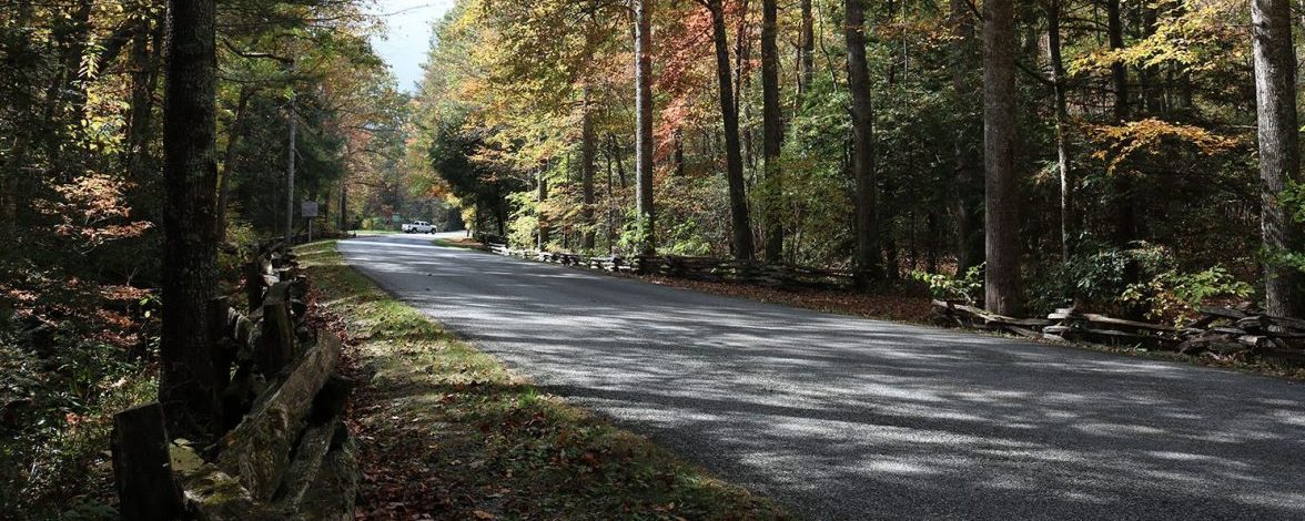
The North Carolina mountains and foothills are laced with Scenic Byways, roads designated by the federal government and state government for their outstanding archaeological, cultural, historic, natural, recreational and scenic qualities. Scenic byways take travelers through National Park land, National Forests, rustic valleys and peaceful farmland to breathtaking mountain vistas, waterfalls, scenic small towns, vineyards, and historic sites.
Blue Ridge Parkway
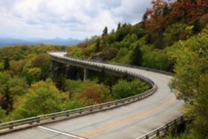 Perhaps the most famous scenic byways in the North Carolina mountains is the Blue Ridge Parkway. Built during the Depression, the road was designed from the outset to be a meandering drive through the Appalachians from Virginia to Western North Carolina. Frequent turnouts, hiking trailheads and picnic spots give travelers ample opportunity to fully enjoy the beauty of the mountains.
Cherohala Skyway
It took 30 years to construct this paved 50-mile, two-lane road that climbs to elevations of over 5,300 feet between Robbinsville, North Carolina and Tellico Plains, Tennessee. This ridge route gets its name from the two National Forests it crosses: the Cherokee National Forest and the Nantahala National Forest. In North Carolina, travelers look down on stunning views of the Appalachian Mountains, Snowbird, Slickrock, and Joyce Kilmer Forests and on clear days can see the Great Smoky Mountains in the distance. The nearby “Tail of the Dragon,” a stretch of US Highway 129, has 318 curves in 11 miles and is America’s number one motorcycle and sports car road.
Smoky mountain region (including Franklin):
State Highway 281 between Sapphire and the South Carolina border is known as Whitewater Way, taking its name from Whitewater Falls, the highest waterfall east of the Rockies and one of many waterfalls in this southern region of the Nantahala National Forest.
Central mountain region (including Asheville):
Length: 45 miles
Drive Time: 1.5 hours
For a detailed driving route and map, download the NC Department of Transportation’s Scenic Byways guide.
Length: 31 miles
Drive Time: 45 minutes
For a detailed driving route and map, download the NC Department of Transportation’s Scenic Byways guide.
Length: 16.5 miles
Drive Time: 25 minutes
For a detailed driving route and map, download the NC Department of Transportation’s Scenic Byways guide.
From Weaverville, birthplace of Civil War governor Zebulon Vance, to Alexander and then north on US 251 to just past Marshall, this Scenic Byway winds through rolling hills and peaceful farmland along the French Broad River. The French Broad, which begins in Rosman and runs a northerly course into Tennessee, is one of North Carolina’s most popular waterways for rafting, fishing and other water sports.
Length: 17 miles
Drive Time: 25 minutes
For a detailed driving route and map, download the NC Department of Transportation’s Scenic Byways guide.
The Historic Flat Rock Scenic Byway consists of several roads in the Flat Rock community, near Hendersonville. The village was a popular haven for affluent Charlestonians, Europeans and plantation owners. The eight-mile byway leads past many beautiful historic homes, the St. John in the Wilderness gothic revival church, the Flat Rock Playhouse, the Historic Woodfield Inn, and the Carl Sandburg Home National Historic Site.
Length: 8.3 miles
Drive Time: 20 minutes
For a detailed driving route and map, download the NC Department of Transportation’s Scenic Byways guide.
Located in some of North Carolina’s highest terrain, the Interstate 26 Scenic Highway in Madison County takes motorists straight through the heart of the Appalachian Mountains and offers stunning views, as well as engineering and environmental wonders.
Length: 10 miles
Drive Time: 20 minutes
For a detailed driving route and map, download the NC Department of Transportation’s Scenic Byways guide.
High Country and foothills (including Boone):
Length: 18 miles
Drive Time: 45 minutes
Note: The route is not recommended for recreational vehicles or buses.
For a detailed driving route and map, download the NC Department of Transportation’s Scenic Byways guide.
Length: 17 miles
Drive Time: 45 minutes
For a detailed driving route and map, download the NC Department of Transportation’s Scenic Byways guide.
Stunning and varied scenery awaits travelers along this scenic byway. Stretching from the high country of Boone to Laurel Springs, the Byway follows State Roads 194 and 88 on what once was the “Old Buffalo Trail.” Along the way, visitors will see one of the oldest rivers in the world, ironically named the “New River,” and pass the largest concentration of Christmas tree farms in the country.
Length: 35 miles
Drive Time: 75 minutes
Note: The route is not recommended for recreational vehicles or buses.
For a detailed driving route and map, download the NC Department of Transportation’s Scenic Byways guide.
Length: 33 miles
Drive Time: 45 minutes
For a detailed driving route and map, download the NC Department of Transportation’s Scenic Byways guide.
Length: 25 miles
Drive Time: 40 minutes
For a detailed driving route and map, download the NC Department of Transportation’s Scenic Byways guide.
For detailed driving routes and maps, download the NC Department of Transportation’s Scenic Byways guide.